About the National Tidal and Sea Level Facility
The National Tidal and Sea Level Facility (NTSLF) is the UK centre of excellence for sea level monitoring, coastal flood forecasting and the analysis of sea level extremes. It is the focus for sea level research in the UK and for its interpretation into advice for policy makers, planners and coastal engineers.
 Rising sea levels and possible future changes to our storm climate have profound implications for coastal protection and marine management. Global sea level is expected to rise by between 30–80 cm by the year 2100 (depending on greenhouse gas emissions) and this will change the frequency and severity of coastal flood events. Managing the risk and developing effective forecasting systems demands the best understanding of the science behind global sea level rise, its regional variability, tides, storm surges and coastal inundation. It is also essential to maintain a robust system for sea level monitoring.
These web pages provide real time displays of UK sea levels, forecasts from the operational storm surge model, and measurements from the south Atlantic and Gibraltar. We also maintain the national archive of quality controlled tide gauge data, and predictions from the operational surge model for previous events.
The NTSLF is based at the National Oceanography Centre (NOC) in Liverpool, an international leader in sea level research. With research partners in the Met Office, coastal engineering consultancies and top universities we provide unrivalled expertise in:
- sea level measurement
- tide gauge technology and telemetry
- numerical modelling of tides, storm surges and waves
- statistical estimation of extreme sea levels.
We are also responsible for monitoring sea level at strategic sites in the south Atlantic, and in the British Overseas Territories, as the UK contribution towards international climate change research. Following the 2004 Boxing Day tsunami in the Indian Ocean, NTSLF scientists and engineers helped enhance the tide gauge network around Africa to provide a better understanding of extreme sea level events in this developing region.
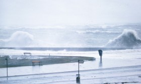
NOC scientists with colleagues at the Met Office continuously improve the accuracy of tide, surge and wave numerical models used for coastal flood warning. The models run four times a day, making predictions up to five days ahead. In 2010 we developed an ensemble storm surge prediction system to quantify the inherent uncertainty in model outputs and thus provide increased forecast confidence. The storms that battered the UK during December 2013 and January 2014 marked some of the most severe weather in recent years. During the 5th and 6th December, sea levels in parts of the North Sea were the highest since the 1953 floods and the Thames Barrier and Dutch flood barriers were closed for several tides. The fact that the damage was so limited during the December 2013 storm is thanks to advances in the modelling systems and also to significant government investment in coastal defences, flood forecasting and sea level monitoring.
Our work is of strategic importance to government, local authorities, the public and the scientific community. We ensure that scientific advances in sea level prediction and coastal flood forecasting are communicated rapidly to all stakeholders. We provide crucial input on waves, storm surges and sea level to the UK Marine Climate Change Impacts Partnership. Our sea level scientists have been contributing or lead authors for each assessment report of the Intergovernmental Panel on Climate Change (IPCC).