Lerwick tide gauge site
The tide gauge building and pressure points are located on the inner wall at the breakwater entrance to the small boat harbour,
south of Victoria Pier, Lerwick.
Click here
to see a map of the site in a separate window.
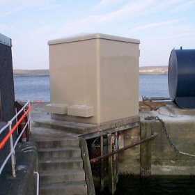
Tide gauge location
The tide gauge equipment is housed in a GRP building mounted over the stilling well. The stilling well was used for the operation of the Lea Gauge but it is no longer in service. The present system is a pneumatic bubbler consisting of two full-tide and mid-tide pressure points mounted on steelwork attached to the harbour wall. All three pressure lines are monitored by the POL data logger.
 The tide gauge is levelled to the tide gauge bench mark supported by Ordnance Survey auxiliary marks.
External users
Sea level pressures and/or elevations from this site are supplied to the following authority:
- Lerwick Port Authority, Port Control
Site history
1956 – Temporary Munro gauge installed by National Institute of Oceanography
1963 – Lea vertical gauge installed
1965 – Temporary Munro gauge removed
1989 – New wooden tide gauge building erected; the DATARING system was connected to the Lea gauge and a single full tide bubbler system
1995 – Tide gauge system upgraded with the installation of two full-tide and a mid-tide measuring system; the Lea gauge was replaced with an Ott pneumatic gauge
2002 – POL data logger installed mid-tide bubbler installed
2002 – Tide Gauge building and all equipment destroyed by fire
2003 – New GRP tide gauge building erected, and new steelwork with two full-tide and a mid-tide measuring system and met instruments were installed and connected to the POL data logger
| Location | |
| Latitude | 60° 9.244'N |
| Longitude | 1° 8.413'W |
| Grid ref | HU 4783 4137 |
| Earliest data | 1956 |
| Tidal levels | |
| HAT | 2.48 m |
| LAT | 0.00 m |
| MHWS | 2.17 m |
| MHWN | 1.68 m |
| MLWN | 0.94 m |
| MLWS | 0.44 m |
| H for 2024 | 2.48 m |
| L for 2024 | 0.02 m |
| H for 2025 | 2.44 m |
| L for 2025 | 0.05 m |
| MSR | 1.73 m |
| MNR | 0.74 m |
Abbreviations
HAT – highest astronomical tide
LAT – lowest astronomical tide
MHWS – mean high water springs
MHWN – mean high water neaps
MLWN – mean low water neaps
MLWS – mean low water springs
H – highest for year
L – lowest for year
MSR – mean spring range
MNR – mean neap range
Measurement devices
Tide gauge systemsFull-tide bubbler
Half-tide bubbler
Direct pressure transducer
Tide gauges
Ott pneumatic gauge
Munro float gauge
Wellhead float gauge
Lea float gauge
Instruments
DATARING logger
Datum probe