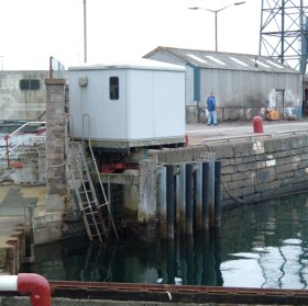
Wick tide gauge site
The tide gauge building is mounted over an unused stilling well at the end of Wick Harbour next to the ship repair slipway. The
pressure points are located directly beneath the building.
Click here
to see a map of the site in a separate window.
Tide gauge location
The tide gauge equipment is housed in a GRP building and consists of a pneumatic bubbler system with two full-tide and a mid-tide pressure points mounted on steelwork attached to the stilling well. All three pressure lines are monitored by the POL data logger. A pressure signal is also supplied to an Ott pneumatic gauge for the Harbour.
 The tide gauge is levelled to the tide gauge bench mark support by Ordnance Survey auxiliary marks.
External users
Sea level pressures and/or elevations from this site are supplied to the following authority:
- Wick Harbour
Site history
1964 – Lea gauge installed
1985 – The wooden tide gauge building was refurbished, and the DATARING system was installed; the Lea gauge was replaced with a Munro gauge and a single pneumatic bubbler system
1995 – All equipment removed from site for installing a new GRP tide gauge building – on completion the DATARING system was reinstalled: new steelwork was fitted supporting two full-tide and a mid-tide measuring system with an Ott pneumatic gauge
2001 – POL data logger installed
| Location | |
| Latitude | 58° 26.458'N |
| Longitude | 3° 5.179'W |
| Grid ref | ND 3668 5081 |
| Earliest data | 1964 |
| Tidal levels | |
| HAT | 3.97 m |
| LAT | 0.06 m |
| MHWS | 3.51 m |
| MHWN | 2.78 m |
| MLWN | 1.43 m |
| MLWS | 0.63 m |
| H for 2024 | 3.96 m |
| L for 2024 | 0.07 m |
| H for 2025 | 3.88 m |
| L for 2025 | 0.12 m |
| MSR | 2.88 m |
| MNR | 1.35 m |
Abbreviations
HAT – highest astronomical tide
LAT – lowest astronomical tide
MHWS – mean high water springs
MHWN – mean high water neaps
MLWN – mean low water neaps
MLWS – mean low water springs
H – highest for year
L – lowest for year
MSR – mean spring range
MNR – mean neap range
Measurement devices
Tide gauge systemsFull-tide bubbler
Half-tide bubbler
Direct pressure transducer
Tide gauges
Ott pneumatic gauge
Munro float gauge
Wellhead float gauge
Lea float gauge
Instruments
DATARING logger
Datum probe