Ilfracombe tide gauge site
The tide gauge building is located in the corner of the harbour car park. The pressure points are fixed on the seaward end of the
low jetty.
Click here
to see a map of the site in a separate window.
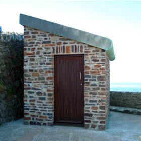
Tide gauge location
The tide gauge building contains the pneumatic control panel and POL data logging equipment.
 The tide gauge is levelled to the tide gauge bench mark supported by Ordnance Survey auxiliary marks.
External users
- Environment Agency, South West Region
- Environment Agency, Southern Region
- Environment Agency, Midlands Region
- Environment Agency Wales / Asiantaeth yr Amgylchedd Cymru
Site history
1968 – Lea gauge installed
1973 – Ott punch tape recorder installed, Lea gauge removed
1983 – Ott recorder removed
1983 – DATARING system installed with full tide pressure point and Wellhead unit
1991 – Building removed after storm damage to the pier
1991 – Building and DATARING system reinstalled
1992 – Mid-tide pressure point installed
2000 – Tide gauge building removed for the demolition of the pier
2000 – Temporary tide gauge established in a cabinet on the harbour car park
2002 – Tide gauge system relocated to the new tide gauge building – two full-tide and mid-tide pressure points were fixed to the low jetty wall
| Location | |
| Latitude | 51° 12.668'N |
| Longitude | 4° 6.743'W |
| Grid ref | SS 5255 4789 |
| Earliest data | 1968 |
| Tidal levels | |
| HAT | 10.26 m |
| LAT | -0.09 m |
| MHWS | 9.27 m |
| MHWN | 6.99 m |
| MLWN | 3.11 m |
| MLWS | 0.86 m |
| H for 2024 | 10.17 m |
| L for 2024 | -0.07 m |
| H for 2025 | 10.01 m |
| L for 2025 | 0.06 m |
| MSR | 8.41 m |
| MNR | 3.88 m |
Abbreviations
HAT – highest astronomical tide
LAT – lowest astronomical tide
MHWS – mean high water springs
MHWN – mean high water neaps
MLWN – mean low water neaps
MLWS – mean low water springs
H – highest for year
L – lowest for year
MSR – mean spring range
MNR – mean neap range
Measurement devices
Tide gauge systemsFull-tide bubbler
Half-tide bubbler
Direct pressure transducer
Tide gauges
Ott pneumatic gauge
Munro float gauge
Wellhead float gauge
Lea float gauge
Instruments
DATARING logger
Datum probe