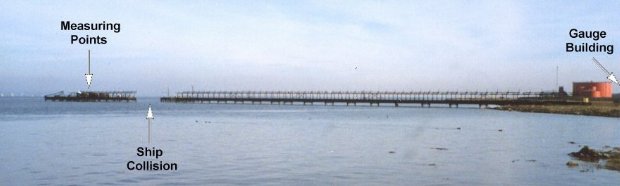
Avonmouth tide gauge site
The tide gauge building is located on land between the wartime jetty and the fuel storage depot, with the measuring points being
attached to the superstructure of the wartime Jetty.
Click here
to see a map of the site in a separate window.
Tide gauge location
The tide gauge equipment is housed in a GRP building with the power and signal wires running under the land, along the jetty and down to the transducers. Both signal lines are monitored by the POL data logger.
The tide gauge is levelled to the tide gauge bench mark supported by Ordnance Survey auxiliary marks.
External users
There are currently no external users.
Site history
1984 – DATARING system installed with two full tide bubblers
1984 – A ship collided with the jetty causing extensive damage to the tide gauge
1985 – A temporary tide gauge was installed using an Aanderra gauge
1986 – DATARING system reinstalled with two full tide bubblers
1989 – Pressure points buried in mud; both pressure points lifted clear of the mud
1993 – The pneumatic system was replaced with transducers mounted underwater
2000 – New pressure transducers installed underwater
2001 – New POL data logger installed recording the two full tide sensors
2011 – Site decommissioned – superseded by Portbury (south side of the mouth of the River Avon)
| Location | |
| Latitude | 51° 30.648'N |
| Longitude | 2° 42.906'W |
| Grid ref | ST 5063 7900 |
| Earliest data | 1984 |
| Tidal levels | |
| HAT | 14.65 m |
| LAT | -0.20 m |
| MHWS | 13.33 m |
| MHWN | 9.99 m |
| MLWN | 3.78 m |
| MLWS | 1.06 m |
| H for 2024 | 14.53 m |
| L for 2024 | -0.13 m |
| H for 2025 | 14.28 m |
| L for 2025 | 0.25 m |
| MSR | 12.27 m |
| MNR | 6.21 m |
Abbreviations
HAT – highest astronomical tide
LAT – lowest astronomical tide
MHWS – mean high water springs
MHWN – mean high water neaps
MLWN – mean low water neaps
MLWS – mean low water springs
H – highest for year
L – lowest for year
MSR – mean spring range
MNR – mean neap range
Measurement devices
Tide gauge systemsFull-tide bubbler
Half-tide bubbler
Direct pressure transducer
Tide gauges
Ott pneumatic gauge
Munro float gauge
Wellhead float gauge
Lea float gauge
Instruments
DATARING logger
Datum probe