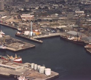
Aberdeen tide gauge site
The tide gauge is located on the south east corner of Waterloo Quay, Aberdeen Docks.
Click here
to see a map of the site in a separate window.
Tide gauge location
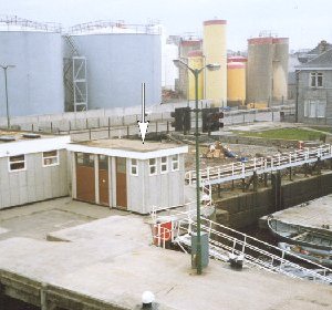
The tide gauge equipment is housed in a brick building which also contains a Munro gauge mounted over a stilling well. The gauge is no longer used and the stilling well has been filled in. The present equipment consists of a pneumatic bubbler system with two full tide and mid-tide pressure points mounted on steelwork attached to a pile under the quay to the left of the lamp post seen in the centre of the photograph. All three pressure lines are monitored by the POL data logger.
 The tide gauge is levelled to the tide gauge bench mark supported by Ordnance Survey auxiliary marks.
External users
Sea level pressures and/or elevations from this site are supplied to the following authorities:
- Aberdeen Port Control
- Grampian Regional Council Water Services Department
- Environment Agency, North East Region
- National Institute for Coastal and Marine Management, Netherlands
Site history
1930 – Cary Porter gauge in use at Pocra Quay
1967 – Munro gauge installed
1973 – Munro gauge moved to its present location
1986 – DATARING system installed, one full tide bubbler, datum probe and potentiometer on the Munro gauge
1993 – DATARING removed from service due to harbour works
1993 – Operation of the Munro gauge ceased and the stilling well filled in
1994 – DATARING installed with two full tide and mid-tide bubblers
2001 – New POL data logger installed recording the two full tide sensors
2004 – Mid-tide sensor connected to the POL data logger
| Location | |
| Latitude | 57° 8.64'N |
| Longitude | 2° 4.818'W |
| Grid ref | NJ 9525 0591 |
| Earliest data | 1930 |
| Tidal levels | |
| HAT | 4.85 m |
| LAT | 0.05 m |
| MHWS | 4.32 m |
| MHWN | 3.46 m |
| MLWN | 1.70 m |
| MLWS | 0.70 m |
| H for 2024 | 4.84 m |
| L for 2024 | 0.05 m |
| H for 2025 | 4.76 m |
| L for 2025 | 0.12 m |
| MSR | 3.62 m |
| MNR | 1.76 m |
Abbreviations
HAT – highest astronomical tide
LAT – lowest astronomical tide
MHWS – mean high water springs
MHWN – mean high water neaps
MLWN – mean low water neaps
MLWS – mean low water springs
H – highest for year
L – lowest for year
MSR – mean spring range
MNR – mean neap range
Measurement devices
Tide gauge systemsFull-tide bubbler
Half-tide bubbler
Direct pressure transducer
Tide gauges
Ott pneumatic gauge
Munro float gauge
Wellhead float gauge
Lea float gauge
Instruments
DATARING logger
Datum probe